The Tarcoola Project is located ~70km N/NW of the Tunkillia Project on ~1,640 km2 of tenements, and is the site of the brownfields open pit Perseverance Mine on ML6455 which was operated during 2017 and 2018.
The Perseverance Mine is surrounded by numerous historical high-grade, shallow artisanal mines. During the early 1900’s the Tarcoola Goldfield was South Australia’s major hard rock gold producer, with numerous historical high-grade workings producing some ~2,400kg (~77koz) gold bullion recovered from ~64kt ore at an average grade of ~37.5 g/t Au between ~1900 and ~1955.*
High-resolution aeromagnetic surveys and a regional 2D seismic reinterpretation completed during 2020 have identified a new regional interpreted 3D structural model which is highly prospective for repeats of the deposit model encountered in the Perseverance Mine. Together with additional geophysical analysis the Company has identified a new~14km long target corridor for repeats of the high-grade Perseverance Mine mineralisation. The tenements are historically under-explored with little modern drilling, and have significant discovery potential.
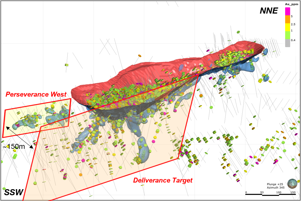
Initial test drilling around the Perseverance Mine during 2020 also yielded positive results, further validating the existing ~500m long ‘Deliverance Target’ (below pit and along strike), and discovering a new, shallow ~200m long gold zone immediately adjacent to the Perseverance Mine (‘Perseverance West’).
Barton plans to systematically test near mine and regional targets to unlock the scale potential of Tarcoola.
High-Grade Near Mine Drilling
The main controlling structure of the Perseverance Mine is the Perseverance Shear. Mineralisation at the Perseverance Mine is open to extension along strike and to depth in all directions. Near mine drilling remains limited, but has yielded numerous high-grade modern and historical drilling intercepts which provide priority infill and extensional drilling targets.
During August 2020 Barton completed a 5,328 metre test drilling programme which intercepted southern and down-dip extensions of the ~500m long ‘Deliverance Target’. This programme also identified the new ‘Perseverance West’ gold zone at the SSW end of the Perseverance Mine. Perseverance West appears to be a shallow structure(s) which are sub-parallel to the Perseverance Shear and offset by some ~150m in distance.
Notable recent and historical drilling intercepts include:
Barton Gold August 2020 Programme:
Deliverance Target
- 7m @ 7.75 g/t Au from 95m;
- 2m @ 15.07 g/t Au from 158m; and
- 3m @ 33.7 g/t Au from 220m
Perseverance West
- 4m @ 6.85 g/t Au from 28m; and
- 2m @ 4.30 g/t Au from 29m
Historical Drilling:
- 3m @ 8.99 g/t Au from 28m;
- 5m @ 6.06 g/t Au from 48m;
- 5m @ 20.6 g/t Au from 59m;
- 2m @ 33.8 g/t Au from 82m;
- 2m @ 56.7 g/t Au from 92m;
- 3m @ 10.43 g/t Au from 95m;
- 2m @ 49.1 g/t Au from 126m;
- 10m @ 6.45 g/t Au from 138m;
- 4m @ 14.8 g/t Au from 138m;
- 2m @ 66.8 g/t Au from 155m; and
- 6m @ 43.6 g/t Au from 197m
Near Mine Priority Targets
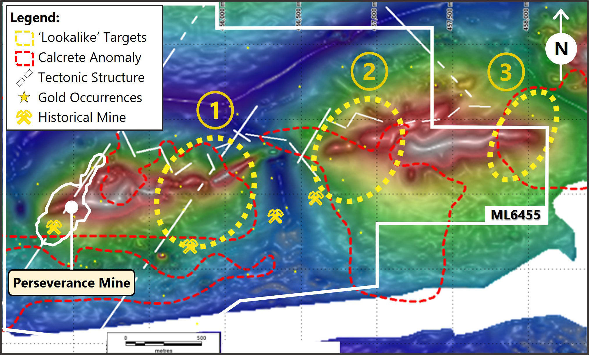
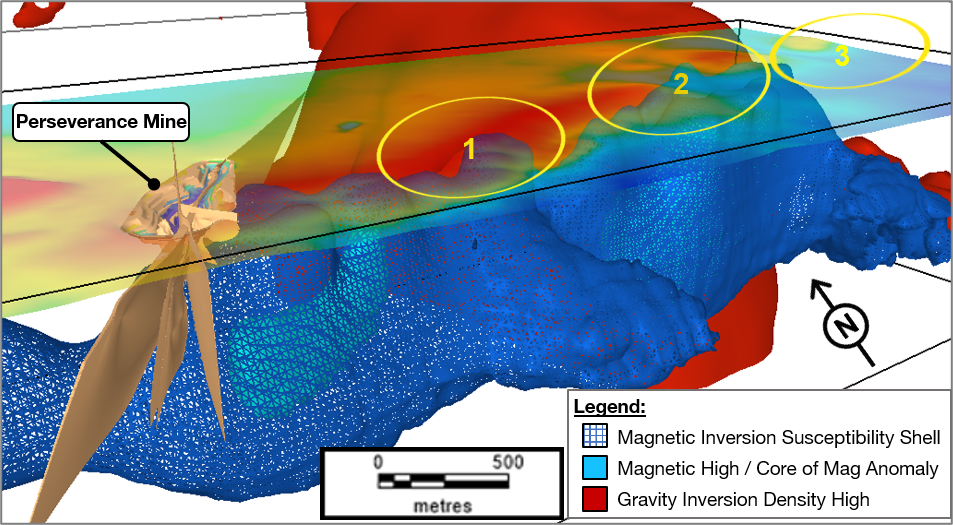
Barton’s 2020 geophysics programmes have identified a new ~4km priority target channel extending east across ML6455 and onto EL6210 which is favourable to hosting potential structural repeats of the Perseverance Mine. The Company has identified three initial priority targets with magnetic signatures analogous to the Perseverance Mine, overlying a magnetic low coincident with local shear / fault structures. These targets also correlate with historical gravity, calcrete, geophysical and structural analyses, overlying shallow high grade drilling intercepts, and shallow historical high grade mines in the vicinity of the Perseverance Mine.
New Regional Model & Targets
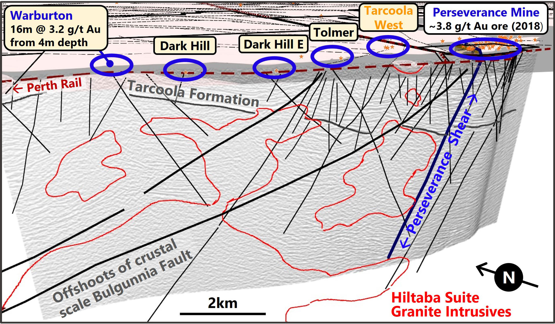
During 2020 Barton commissioned leading international seismic services company HiSeis to undertake a high-definition reprocessing of historical seismic data collected in the vicinity of the Tarcoola Project. The results of the reprocessing were a greatly enhanced understanding of the structural architecture of the local region, including identification of the crustal-scale Bulgunnia Fault, the Tarcoola Formation underlying ML6455 and EL6210, the location and orientation of the major controlling structure at the Perseverance Mine (the Perseverance Shear), and an extensive system of analogous near-surface structures providing priority targets.
The results of this analysis demonstrate that the Perseverance Shear extends from surface, passing through the Tarcoola Formation, to ~7km depth where it intersects one of the Hiltaba Intrusive bodies. It also identified a highly prospective system of parallel shears and faults which are analogous to the Perseverance Shear, effectively extending the newly identified ML6455 ‘target channel’ a further ~10km west across EL6210. There are also numerous structures which appear to intersect or cross-cut these parallel structures.
Several of these newly identified analogous structures correlate with near-surface historical data at existing priority regional exploration targets. The Company intends to undertake further geophysical and geochemical analyses to further refine the interpreted 3D structural model, and then test drill the highest priority target areas.


